
If you open Google Maps while planning a trip to Korea, you may find that getting the detailed directions you expect isn’t always as straightforward.
In Korea, people use several map and navigation apps, including Naver Map, KakaoMap, TMAP, and Google Maps. Even as someone who lives here, I usually turn on a map or navigation app whenever I’m going somewhere unfamiliar, whether I’m taking public transportation or driving.
These days, there’s much less need to stop someone on the street and ask for directions.
With just a starting point and destination, a map app can tell you which bus to take, where to transfer, which subway exit to use, and how to walk the rest of the way.
For someone visiting Korea for the first time, Naver Map is one of the useful options to have on your phone.
Can You Use Naver Map in English?
Yes. Naver Map supports English, along with Korean, Simplified Chinese, and Japanese.
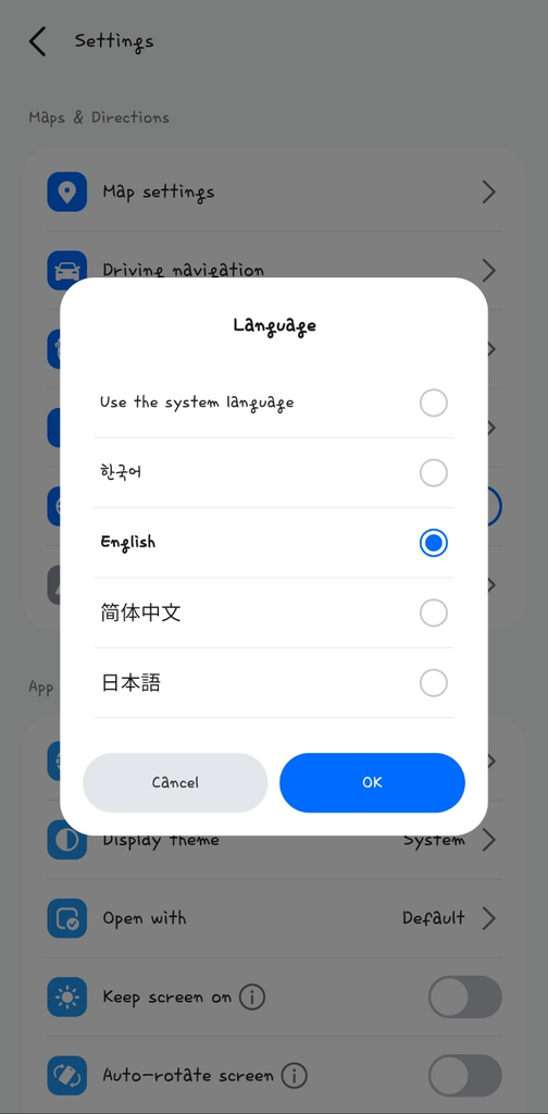
On Android, you can change the language through:
MY → Settings → Language → English
On iPhone, you can change the language through the Naver Map settings or the app-specific language settings on your iPhone.
As of September 2026, Naver Map can be used not only to search for places but also to find public transportation routes and check real-time transit information.
I recommend setting the app to English before you start traveling so you don’t have to figure it out while you’re already trying to get somewhere.
Start With Just Two Things: Where You Are and Where You’re Going
The basic process is simple.
Search for the place you want to visit, select Directions, and set your starting point. You can use your current location or enter another place manually.
For example, suppose you want to travel from your hotel to a café in Seongsu.
Search for the café, set your current location as the starting point, and Naver Map will show possible routes using walking, buses, subways, or a combination of them.
For public transportation, you can compare routes based on factors such as travel time, number of transfers, and walking distance.
That means the fastest route isn’t necessarily the only choice.
If you have heavy luggage and don’t want to walk far, a route with less walking might be better. If changing buses or subway lines feels stressful, you may prefer an option with fewer transfers.

Naver Map Is Especially Useful When Taking a Bus
One of the things I often check while waiting for a bus is its arrival information.
Instead of simply telling you which bus to take, Naver Map can show real-time information for buses and bus stops.
This makes waiting much easier.
You can get a rough idea of how long you’ll need to wait and decide whether you have time to quickly stop at a nearby convenience store or whether you should stay at the bus stop.
After getting on the bus, keeping the map open can also help you see how many stops remain before your destination.
This is especially useful when Korean bus stop names are unfamiliar to you.
If you’re taking a bus in Korea for the first time, you can also read my guide to riding buses in Korea.
Subway Transfers and Exits Matter More Than You Might Expect
One of the most useful things about map apps in Korea, in my experience, is navigating the subway system.
Many subway stations in Seoul are large. Getting off at the correct station is only part of the journey.
Depending on which exit you use, you might end up walking much farther than necessary. At large transfer stations, where you get off the train can also affect how quickly you reach the next subway line.
So when checking a subway route, don’t look only at which line you need.
Pay attention to information about convenient transfer positions and exits as well. It can help you figure out where to get off for an easier transfer and which exit is closest to your destination.
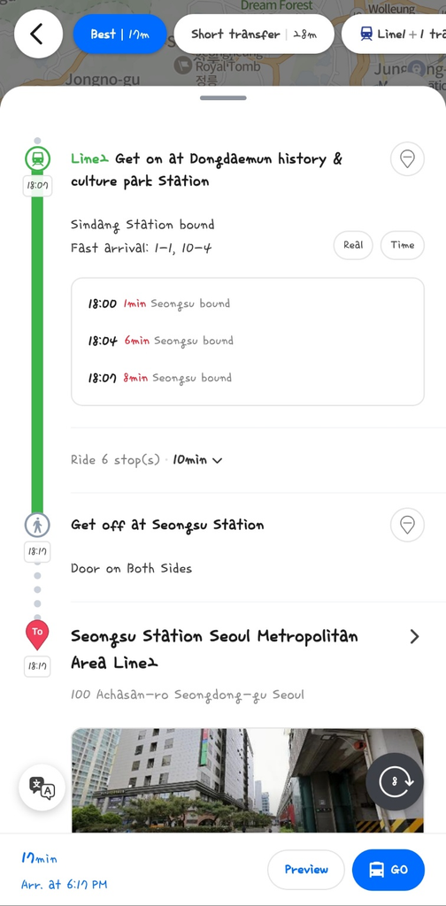
Naver Map also provides subway arrival information through station searches, subway maps, and public transportation directions.
Keep Naver Map Open Until You Reach Your Destination
You don’t have to use a map app only once before leaving.
A typical trip might look like this:
Search for your destination → walk to the correct bus stop or subway station → check arrival information → count the remaining stops → check your transfer → find the correct exit → follow the walking route to your destination.
You can follow most of that journey within the same app.
Public transportation routes also break the trip into different sections, including walking, bus, and subway segments.
So even if Korean place names and transportation systems are unfamiliar, having the correct starting point and destination makes getting around much easier.
Koreans Use Map Apps All the Time Too
Living in Korea doesn’t mean you know every street, bus route, or subway station.
I use map apps when I’m going somewhere unfamiliar too. I check them when taking public transportation, and I use navigation when driving somewhere I haven’t been before.
It’s also common to see people around me using services such as Naver Map, KakaoMap, or TMAP.
In a city like Seoul, where there are many bus routes, subway lines, and possible transfers, it’s often easier to search for the best route at that moment than to memorize everything.
So if you find yourself constantly checking your phone while getting around Korea, that’s completely normal.
People who live here do it too.
A Few Things to Check Before You Go
First, set Naver Map to English and allow location access so the app can identify your current position.
When searching for a destination, double-check the address or branch name. Places with similar names can appear in search results.
For public transportation, don’t stop at checking the basic route. Look at real-time bus arrival information, remaining stops, subway transfers, and exit information when available.
Transit information can also change depending on actual operating and traffic conditions, so leave some extra time when you have an important reservation or schedule.
In the end, navigating Korea with a map app is fairly simple.
Set your starting point and destination, then follow the trip one step at a time: when your bus is coming, where to transfer, how many stops remain, which subway exit to take, and how to walk the final stretch.
Once you get used to checking those details, getting to an unfamiliar place becomes much easier.
Today’s Korean
어디로 가야 해요?
Romanization: Eodiro gaya haeyo?
Easy pronunciation: Eo-di-ro ga-ya hae-yo?
Meaning: “Where should I go?” or “Which way should I go?”
Use this when you’re unsure which direction you should take.
몇 번 출구예요?
Romanization: Myeot beon chulgu-yeyo?
Easy pronunciation: Myeot beon chul-gu-ye-yo?
Meaning: “Which exit is it?”
This is especially useful in a subway station when you need to know which exit is closest to your destination.
여기서 내려요?
Romanization: Yeogiseo naeryeoyo?
Easy pronunciation: Yeo-gi-seo nae-ryeo-yo?
Meaning: “Do I get off here?”
You can use this on a bus or subway when you want to confirm whether this is your stop.
Want to practice real Korean with me? 🇰🇷
Learn natural Korean conversation with K-Unnie — the kind Koreans actually use in everyday life.
Book a Korean lesson with me →